Watch: Tornado crosses Iowa interstate on live TV
Several tornadoes were reported across the Plains on Friday, which were part of a multi-day severe weather threat covering over 60 million Americans.
During the afternoon, FOX Weather Storm Tracker Corey Gerken captured video of one of the powerful tornadoes crossing Interstate 80 outside of Lincoln, Nebraska.
After the supercell moved through, damage was reported in the town of Waverly and several semi-trucks were reported flipped on local interstates.
"Big day today. Really big day tomorrow," FOX Weather Meteorologist Britta Merwin said Friday morning. "In fact, the warning for severe weather is even more dire as we go into Saturday."
WHY DOES THE SKY SOMETIMES TURN GREEN DURING THUNDERSTORMS?
Tornado Watches have been issued by the Storm Prediction Center from eastern Nebraska through East Texas and cover at least half a dozen states.
There is a chance of a few additional tornadoes, scattered damaging wind gusts up to 70 mph, and potential isolated large hail events up to tennis-ball size.

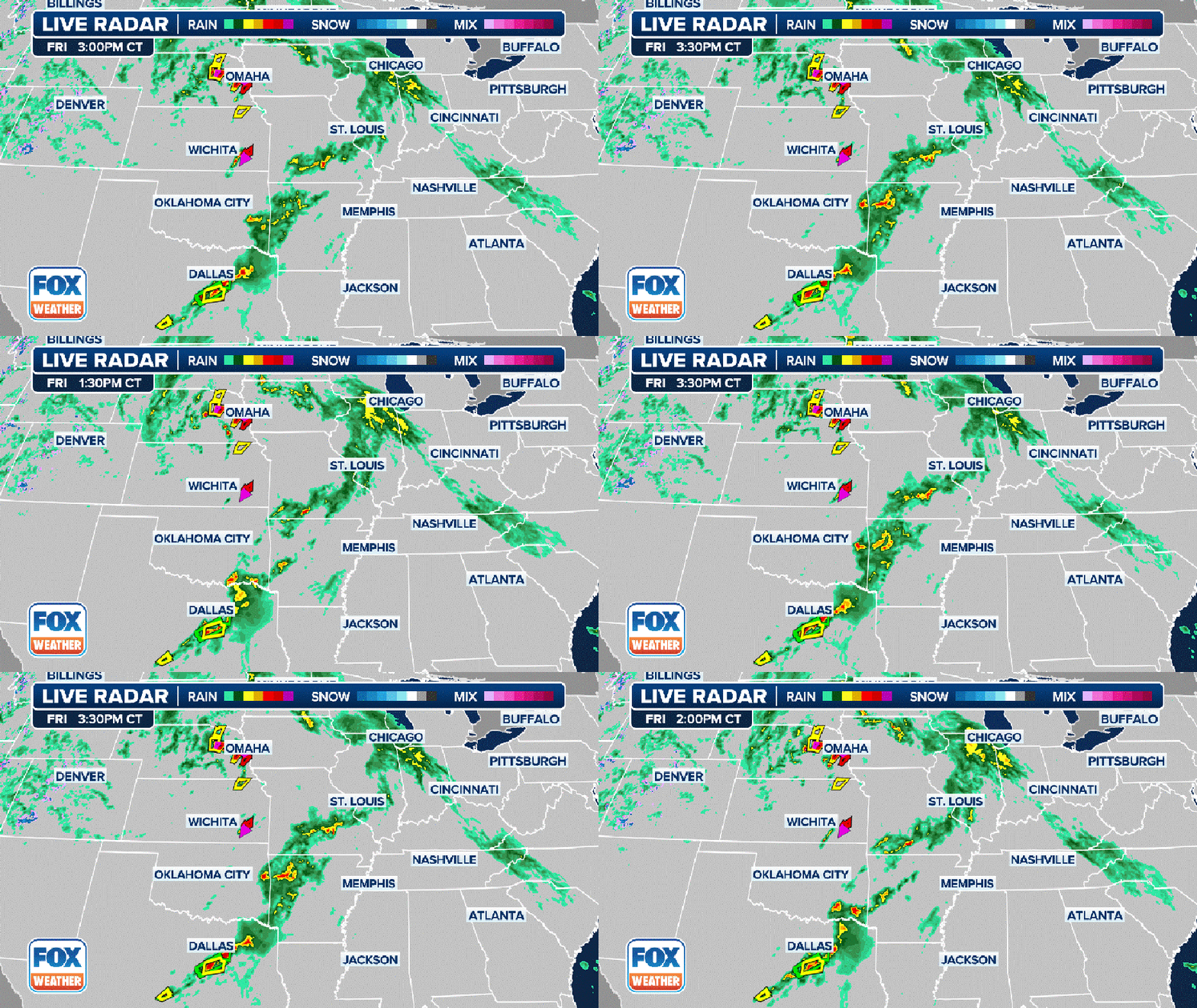
A three-hour radar loop showing where showers and thunderstorms are ongoing. Severe Thunderstorm Warnings are indicated in yellow. Tornado Warnings are indicated in red, while Tornado Warnings with a confirmed tornado are indicated in purple. Flash F
WATCH VS. WARNING: HERE ARE THE DIFFERENCES BETWEEN THESE WEATHER TERMS THAT COULD SAVE YOUR LIFE
"Some of these tornadoes could be an EF-2 or stronger. That means damage would be expected," Merwin said. "If you have an EF-2 roll through your neighborhood, you're not talking about a fence coming down. You're talking about parts of your home no longer being there. So these are aggressive alerts that are meant to really give you a heads-up and help you plan your day."
The threat of tornadoes comes after severe storms impacted eastern Colorado and western Kansas less than 24 hours ago. NOAA's Storm Prediction Center received nearly 100 reports of severe weather, including baseball-sized hail that damaged windows in Brewster, Kansas.
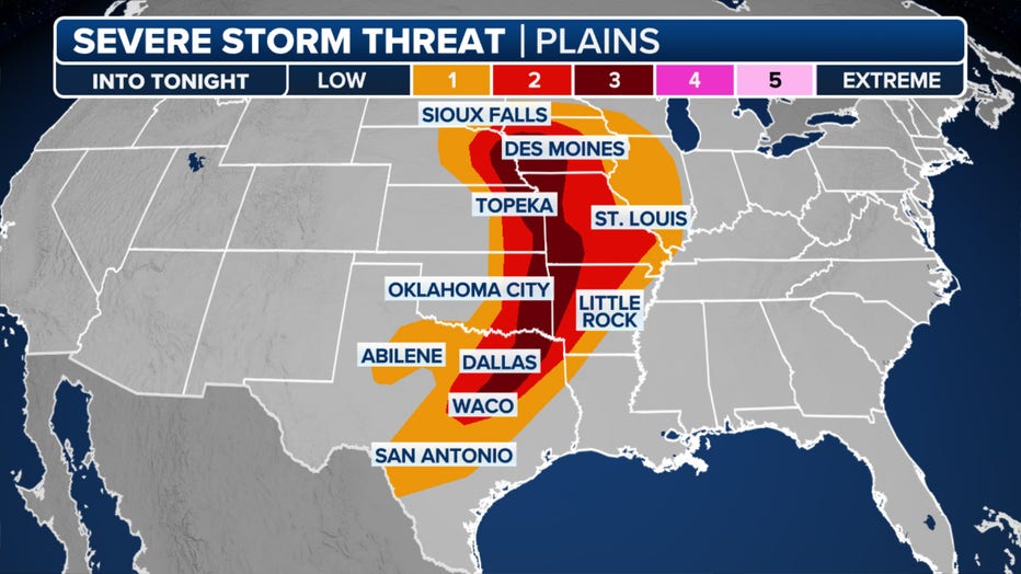
Severe thunderstorms will be likely in parts of eastern Nebraska into western and central Iowa and southward into eastern Kansas and Northwest Missouri Friday. A more isolated severe threat will extend south-southwestward into parts of the southern Plains, Ozarks and Ark-La-Tex from late afternoon into the evening.

This graphic shows the severe weather threat on Friday, April 26, 2024. (FOX Weather)
Over 4.8 million people reside in Level 3 out of 5 severe weather threat zones established by the SPC, including those in Overland Park, Kansas; Kansas City, Missouri; Omaha and Lincoln, Nebraska; and Des Moines, Iowa.
"As we look at the board, notice that there is a highlighted spot up to the north," Merwin said. "Most likely a lot of our Tornado Warnings are going to be later today. With that said, the threat is there the whole day."
WHAT TO DO IF A TREE FALLS ON YOUR HOUSE
Severe storm, flooding threat intensifies Saturday
By Saturday, the severe weather threat is even greater and more expansive.
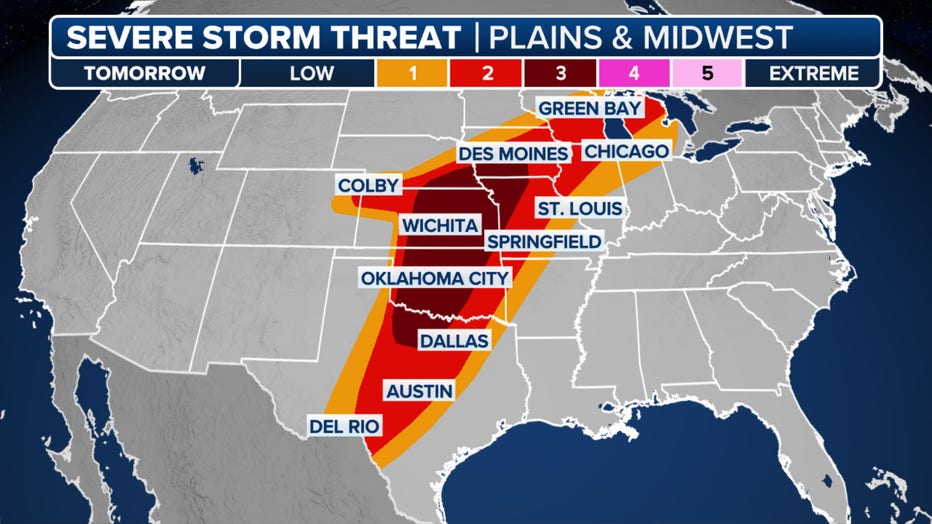
Potentially widespread strong to severe thunderstorms are expected throughout the day and into the night. The FOX Forecast Center said the greatest threat is currently anticipated across parts of the central and southern Plains, where strong tornadoes, very large hail, and damaging winds are possible.
However, the overall threat extends to a large portion of the central U.S., covering over 55 million people from south-central Texas through Michigan.

This graphic shows the severe weather threat on Saturday, April 27, 2024. (FOX Weather)
"The storm itself is getting a dropkick in from the West ... that's why tomorrow (Saturday) is a bigger deal," Merwin said. "We have a more potent system. We have more upper-level support. The ingredients are a bigger deal tomorrow."
In addition to potentially destructive storms, those across the central states will have an ever-increasing risk of flash flooding to contend with. The initial storm, which has already brought flash flooding to southwest Missouri and the Little Rock area, will lay the groundwork for a dangerous day of flash flooding Saturday across the central and southern Plains.
A level 3 or 4 risk for flash flooding highlights numerous instances of flash flooding. Storms are expected to "train" or move over the same areas repeatedly, allowing more than 5 inches of rain to fall in just a few hours. In total, multiple inches of rain could fall in over 15 states.
If there's any silver lining, the rain will greatly benefit the drought currently ongoing in Kansas and Iowa.

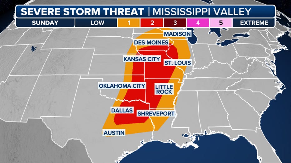
This graphic shows the severe weather threat on Sunday, April 28, 2024. (FOX Weather)
As the system continues moving eastward, the risk of severe thunderstorms on Sunday will stretch from northeastern Texas to parts of the Upper Midwest. Once again, these storms will pack threats of tornadoes, large hail and damaging wind gusts.
Even beyond the risk of severe weather through this weekend, the pattern will likely remain conducive for intense storms as the calendar turns to May next week, the FOX Forecast Center said.
LINK: GET MORE ON THIS STORY FROM FOXWEATHER.COM

