

Hurricane Helene could bring 'catastrophic' flooding to Southeast, mid-Atlantic
While Florida braces for Hurricane Helene, the size of the storm means widespread impacts will be felt across the eastern U.S. late this week, including damaging winds, flooding rain and possible tornadoes in states well into the Southeast, mid-Atlantic and Midwest after landfall.
On its current track, the National Hurricane Center (NHC) said Hurricane Helene is forecast to make landfall along the Florida Big Bend on Thursday evening as a Category 3 hurricane with winds of at least 115 mph. After landfall, Helene is forecast to slow down and turn northwest, moving over the Southeast through Friday and Saturday.
TRACKING HELENE: LIVE FORECAST CONE, SPAGHETTI MODELS, ALERTS, WIND PROJECTIONS AND MORE
The large storm will bring widespread heavy rain, damaging winds and possible tornadoes to cities in the Southeast, including Atlanta and Asheville, North Carolina. Ahead of those impacts, the governors of Georgia, South Carolina and North Carolina have declared states of emergency.
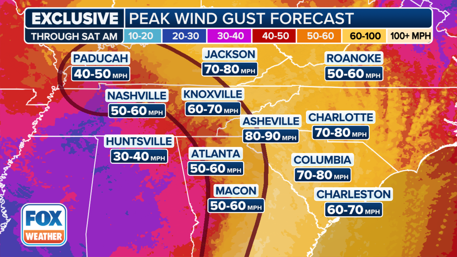
Helene wind forecast for the Southeast. (FOX Weather)
Atlanta is under a Tropical Storm Warning, meaning it could experience tropical storm conditions just hours after Helene's landfall.
Tropical-storm-force winds will be felt in South Carolina as soon as Thursday and across the Southeast through Saturday, with peak gusts up to hurricane strength in parts of Georgia and South Carolina. Helene is expected to track northwest into Kentucky and Tennessee, bringing gusty winds of up to 70 mph.
The NHC is also warning a tornado or two may occur Wednesday in parts of the western Florida Peninsula and southern Alabama. The risk of tornadoes will increase Thursday, expanding across Florida and into parts of Georgia and South Carolina.
Significant to catastrophic flooding possible through this weekend
The biggest implications for Helene post-landfall will be the rain totals forecast across multiple states from Georgia to Kentucky and Virginia as Helene taps into available moisture in the Southeast and pushes toward the Appalachian Mountains.
"The wind going up to the mountains has nowhere to go but up. As it goes up, like a sponge or a towel, just wrings out all of the moisture. And that adds to the rainfall totals, which is why I think we are easily going to see some of these totals closer to 1 foot of rain," FOX Weather Meteorologist Craig Herrera said. "Not only that, but the track of the storm, as we know it, goes back and over portions of Tennessee. So having said that, you've got some reemergence of more rain here. So, you factor in the orographic lift, squeezing out the moisture, that's just going to add the insult to injury, especially since we have rainfall in today already."
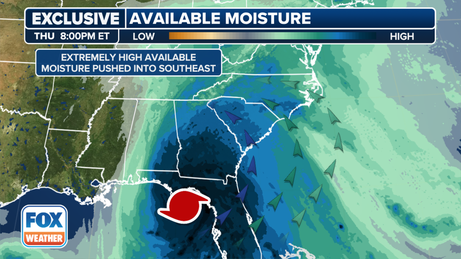
Available moisture in the Appalachians. (FOX Weather)
The NHC is warning of total rain accumulations of 5-10 inches with isolated totals near 15 inches. Cities such as Atlanta and Augusta in Georgia and Knoxville and Chattanooga in Tennessee are among those at the greatest flash flooding risk over the next five days.
"Catastrophic and life-threatening flash and urban flooding, including landslides, is expected across portions of the southern Appalachians through Friday," NHC forecasters wrote in a discussion about Helene. "Considerable to locally catastrophic flash and urban flooding is likely for northwestern and northern Florida and the Southeast through Friday. Widespread minor to moderate river flooding is likely, and isolated major river flooding is possible."
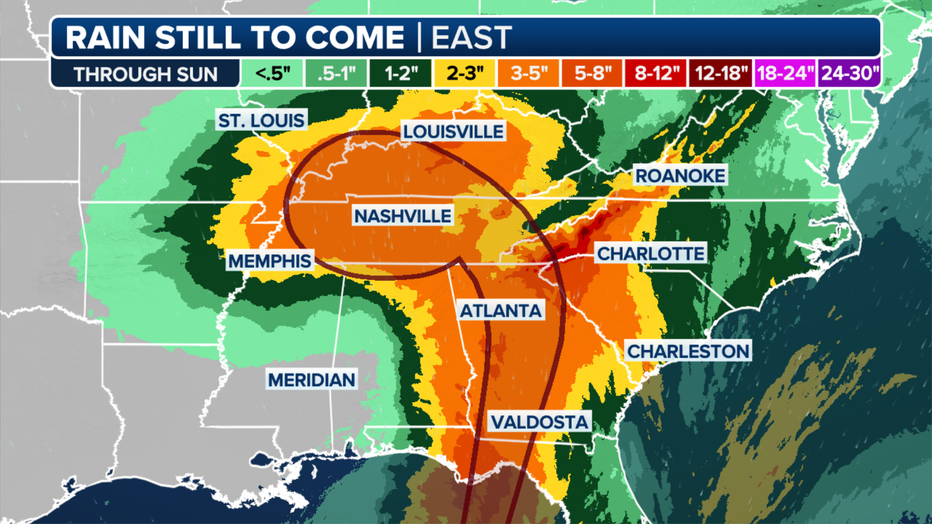
Forecast rain totals. (FOX Weather)
National Weather Service offices across the Southeast, including Greenville, South Carolina, are issuing Flood Watches and Warnings to warn residents of potentially catastrophic flooding. Ahead of Helene's rainfall, the region is expected to get several inches of rain from thunderstorms.
"All this precipitation is expected to occur before the rainfall associated with Helene begins moving into our area on Thursday," forecasters at the NWS office in Greenville-Spartanburg wrote in their Wednesday discussion. "Thus, more widespread flooding is likely with this tropical system. Please remain weather aware over the next few days, the potential for major to catastrophic flooding over parts of our forecast area is looking more likely."
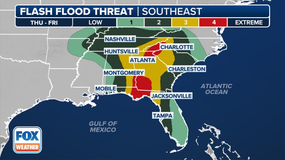
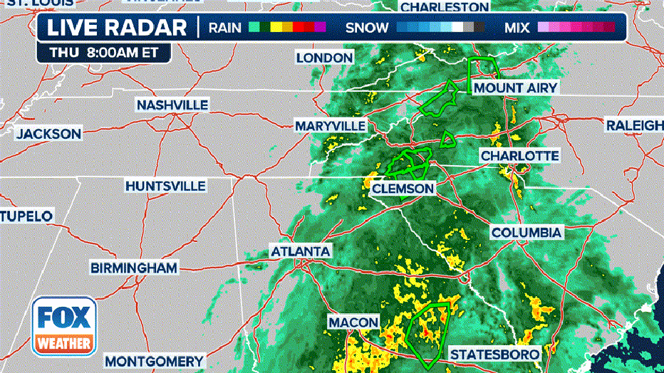
Flash flood outlook for Thursday. (FOX Weather)
Prepare for travel delays
Travelers should also prepare for delays through the weekend. Atlanta International Airport is warning airline travelers that the impacts could have a ripple effect across the Southeast.
FLIGHT DISRUPTIONS IMPACT ATLANTA, TAMPA AS HURRICANE HELENE LOOMS
LINK: Get updates on Helene and more at foxweather.com.